Denver sits on a complex patchwork of Pleistocene alluvial terraces, expansive Pierre Shale, and wind-deposited loess that can make compaction a moving target. Elevations across the metro area range from 5,130 to over 5,400 feet, and this semi-arid climate means moisture-conditioning soils is a constant battle on commercial pads and roadway subgrades alike. A field density test using the sand cone method is the direct way to verify that each lift hits the 95% modified Proctor threshold before the next layer goes down. We run these tests on trench backfills in LoDo brownfield sites, structural fill beneath tilt-up warehouses near DIA, and utility bedding along the I-70 corridor, pairing the density check with a Proctor curve to establish the target dry density for the specific borrow source. The sand cone delivers a physical volume measurement that no nuclear gauge can dispute—critical when a City and County of Denver inspector is watching.
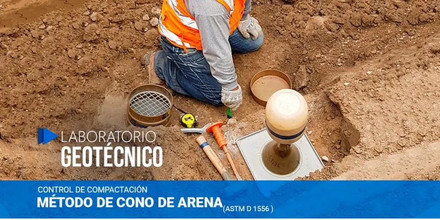
A sand cone test measures the one thing that matters most in earthwork: the actual pounds per cubic foot of compacted soil, not a proxy.
Methodology and scope
Local considerations
Southeast Aurora subdivisions built on deep, dry loess behave entirely differently from the saturated alluvial clays along the South Platte River near Globeville. In the loess, collapsible fabric can hold a 95% compaction test result at low moisture, yet settle abruptly when a lawn irrigation system raises the water content over two seasons. The sand cone test gives us a snapshot of the as-placed density, but it takes judgment to interpret that number against site geology. In the Platte floodplain, organic silts and high groundwater complicate excavation; the sand cone hole can slough before the pour, introducing negative volume error that inflates the apparent density. We cross-check with Atterberg limits to flag high-plasticity clays that shrink and swell with moisture cycling, and we recommend grain-size analysis when the fill contains oversize particles that skew the Proctor reference curve. Without these correlations, a passing density test can still mask a fill that will heave or consolidate under load.
Applicable standards
ASTM D1556-15e1, ASTM D698-12e2, IBC 2021 Section 1805, AASHTO T 191, ASTM D2216-19
Associated technical services
Structural Fill Verification
Layer-by-layer sand cone testing on building pads, retaining wall backfill, and bridge approach embankments, with immediate pass/fail reporting to the grading contractor and geotechnical engineer of record.
Utility Trench Compaction
In-place density tests at pipe-zone, haunch, and cover levels per City of Denver Standard Specifications, including recomputation of relative compaction against the approved Proctor curve for imported bedding sand.
Pavement Subgrade QA/QC
Density testing on subgrade and aggregate base course prior to asphalt or concrete paving, with documentation formatted for CDOT and municipal acceptance.
Typical parameters
Frequently asked questions
What does a sand cone field density test cost in Denver?
A single sand cone test on a Denver-area site typically runs between US$90 and US$170 per point, depending on mobilization distance, number of tests per day, and whether we provide the Proctor curve or the contractor supplies it. Full-day rates for continuous QA/QC observation with testing reduce the per-point cost.
How deep can the sand cone method test?
The test hole is typically excavated 4 to 8 inches deep, corresponding to the thickness of one compacted lift. For deeper verification we advance through successive lifts individually; the method itself is not suited to depths exceeding about 10 inches because the calibrated sand flow becomes less reliable in narrow, deep cavities.
Which standard applies to sand cone testing?
ASTM D1556 is the governing standard in the United States, with AASHTO T 191 used on federally funded highway projects. Both specify the calibration procedure for the sand, the excavation technique, and the calculation for in-place dry density and relative compaction.
Can you test in gravelly soils near the foothills?
Gravel and cobble-rich fills west of I-25 in the Table Mountain area present challenges because large particles disturb the smooth excavation walls. We use a larger replacement sand volume where feasible and may switch to a water-replacement method or large-scale Proctor (ASTM D1557 with 6-inch mold) to maintain accuracy in coarse materials.