Denver sits right on top of the Denver Basin, where the near-surface geology can flip from hard sandstone of the Dawson Formation to soft, swelling claystone of the Denver Formation within a few hundred feet. That kind of lateral change makes guessing bedrock depth from a few boreholes a risky move. Seismic tomography (refraction/reflection) becomes the practical way to map those interfaces across a whole site. Our field crews work regularly along the Front Range, collecting high-density P-wave and S-wave data, so you get a velocity model you can actually trust for foundation design, excavation planning, or checking rippability before the heavy equipment rolls in.
Combining refraction and reflection on a single spread lets us see both the weathered zone and the competent rock below — without drilling extra boreholes.
Methodology and scope
Local considerations
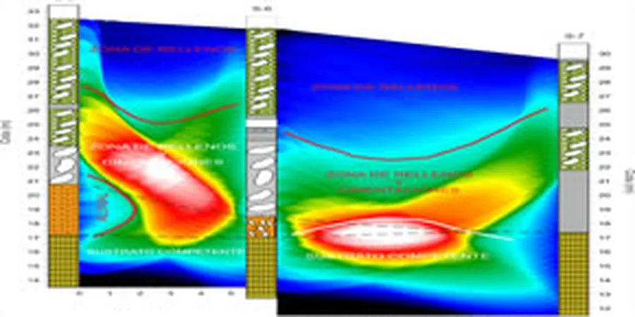
A 6-story mixed-use building over by the South Platte River near Sun Valley was planned with footings at 8 feet, assuming shallow bedrock based on a neighbor’s log from two blocks away. When we ran a refraction line, the velocity model showed a low-velocity lens at 12 to 18 feet — old river channel fill, probably sandy gravel with silt pockets — sitting right under the proposed elevator pit. Without that tomogram, the excavation crew would have hit running groundwater and differential settlement would have shown up within the first two years. Denver’s water table isn’t deep everywhere; near Cherry Creek and the South Platte, it can be as shallow as 10 to 15 feet seasonally, and a reflection survey is what actually confirms whether that blue line on the log is the top of the Arapahoe aquifer or just a perched lens. The cost of a tomography line is a rounding error compared to the change orders that come from guessing wrong.
Applicable standards
ASTM D5777-18: Standard Guide for Using the Seismic Refraction Method, ASTM D7128-18: Standard Guide for Using the Seismic Reflection Method, ASCE/SEI 7-22: Minimum Design Loads — Chapter 20 Site Classification
Associated technical services
Refraction Tomography Survey
Single-line or multi-line P-wave and S-wave refraction with tomographic inversion. Delivered as 2D velocity sections, rippability logs, and depth-to-bedrock contours. Ideal for foundation feasibility, cut-and-fill planning, and verifying borehole interpretations across the Denver Basin formations.
Combined Refraction + Reflection
Same spread, dual processing: refraction for the weathered overburden and reflection for deeper targets (Pierre Shale contact, Arapahoe sandstone top). Includes CMP stacking and migrated depth sections. We use this regularly near Cherry Creek and the Platte River corridor where saturated alluvium creates velocity reversals.
Vs30 and Site Class Determination
S-wave refraction lines processed for average shear-wave velocity in the upper 100 ft per ASCE 7-22. Includes NEHRP site class letter and response spectrum parameters. Often combined with MASW for redundancy on larger Denver projects where the structural engineer wants both data sets.
Typical parameters
Frequently asked questions
How deep can seismic tomography see in the Denver Basin geology?
It depends on the source energy and the method. With a standard weight drop or sledgehammer on a 230 ft spread, refraction typically resolves 30 to 60 feet in Denver’s alluvial and weathered claystone settings. Adding a reflection component and longer offsets can pull bedrock picks from 100 to 200 feet or more, especially when the target is the contact between the Denver Formation and the underlying Pierre Shale or the top of the Arapahoe sandstone.
What’s the typical cost range for a seismic tomography survey in Denver?
For a single refraction line (24 channels, 230 ft spread) with tomographic processing and a summary report, projects around Denver usually fall between US$3.070 and US$5.980. The exact figure depends on line length, whether you need reflection processing on top of refraction, access conditions, and how many shots per spread we have to acquire to meet your depth target.
Can you do seismic surveys inside Denver city limits without shutting down streets?
Yes, we work regularly on vacant lots, parking areas, and within building footprints before construction starts. For work in public right-of-way — say, along Colfax or near the 16th Street Mall — we coordinate with Denver Public Works for the necessary permits and traffic control. On most private sites, no street closure is needed; our crews operate with standard safety cones and flagging.
How do you handle the velocity inversions common in the Denver Formation?
Velocity inversions — where a faster layer overlies a slower one — are exactly what standard refraction first-break picking can miss. We run reflection profiles on the same spread to image those hidden low-velocity zones, and we also use S-wave data, which often sees the stiffness contrast even when the P-wave velocity doesn’t drop. The tomographic inversion then incorporates both data sets so the final model doesn’t artificially push bedrock shallower than it really is. More info.